o Iran’s land suitability for agriculture (million ha): very good 0.6 (0.4%), good 3.6 (2.2%), medium 12.8 (7.9%), poor 18.5 (11.4%), very poor 10.2 (6.3%), unsuitable 97.4 (60%), and excluded areas 19.3 (11.9%).
o Current distribution of croplands among suitability classes (% of total croplands): very good 2%, good 12%, medium 34%, poor 30%, very poor 5%, unsuitable 17%.
o 5.5 million ha of croplands (cultivated and uncultivated) were found in unsuitable and very poor classes; cropping in such lands can result in low yields, or represents an unsustainable practice.
o Informed redistribution of croplands could potentially improve crop yield and sustainability of agriculture in Iran.
Besides the rapid population growth over the past few decades, water scarcity and soil degradation have intensified the challenges faced by the Iranian agriculture sector to ensure food security over the long term. Despite its paramount importance, the extent to which the land and water resources of Iran can meet the nation’s future food demand is not well understood. Herein, we systematically evaluated the capacity of Iran’s land for sustainable agriculture based on the soil properties, topography, and climate conditions relevant to crop production. Our objectives were to: i) Quantify and map the suitability of Iran’s land resources for cropping ii) Examine if further increase in production can be achieved through agriculture expansion or the redistribution of cropping areas When evaluated based on the soil and topographic variables only, Iran’s land suitability for crop cultivation can be classified as (million ha): very good 0.7, good 5.1, medium 17.2, poor 24.8, very poor 55.7, and unsuitable 39.7. Inland water bodies, protected areas, urbanized areas, natural forests, and rangelands, collectively occupying 19.3 million ha of Iran’s land, are recognized in this study as excluded areas. When climate variables (precipitation and potential evapotranspiration) were included in the analysis, the distribution of lands among suitability classes were (million ha): very good 0.6, good 3.6, medium 12.8, poor 18.5, very poor 10.2, and unsuitable 97.4. The spatial distribution of these lands is shown in Figure ES-1. Among the considered soil and terrain attributes, low soil organic carbon, steep slope, and high soil sodium content were identified as the most frequent factors limiting the suitability of lands for cropping.

Figure ES-1. Map of Iran’s land suitability for cropping evaluated based on soil properties, topography, and climate variables.
Our analysis also revealed that 30%, 5%, and 17% of the current agricultural lands (cultivated and uncultivated) are located in poor, very poor, and unsuitable areas, respectively. Cultivation in very poor or unsuitable lands can be partially avoided as there exist unused lands with at least a medium level of suitability for substitution that can improve the overall sustainability of the agriculture sector in Iran. Our estimation of the proportion of unused lands within each suitability classes shows that almost all available lands with high suitability have been exploited for agriculture, but there exist about 4.2 million ha of medium quality lands, mostly located in western Iran, for future expansion. However, only a small portion of these unused lands can be practically deployed for agriculture because of their low spatial connectivity and limited accessibility. We estimated that cultivating rainfed wheat in 1 million ha of these unused lands could potentially result in the production of 0.8 million ton of wheat per year – adding up to 5% to Iran’s current cereal production level. Whilst the insufficiency of water resources has long been realized as a major impediment to developing a productive agriculture in Iran, our study highlights the additional limitations caused by the paucity of suitable land resources. Our analysis does not consider groundwater availability for agriculture and precipitation is the only component of surface water availability considered in this study.
Evaluation of Land and Precipitation for Agriculture in Iran
Introduction Agriculture constitutes one of the major pillars of Iran’s economy by contributing approximately 9% to the gross domestic product (GDP) and providing 18% of the total employment [1]. It supplies about 90% of the domestic food demands and accounts for 92% of the freshwater consumption in the country [1]. Figure 1 shows the changes in Iran’s harvested land area, average crop yield [2][3][4], population, and net international trade over the past 25 years [5]. While the total cultivated cropland area has been fluctuating around 12 million ha over the past 25 years, the average crop yield has increased from 2.8 to 6.4 ton/ha — giving rise to an increase in the annual crop production from 29 to 74 million ton between 1990 and 2015. Nevertheless, the yield and production tonnage of the cereals — which account for 80% of the harvested croplands — have virtually stayed flat and the rise in the average crop yield and total production is solely due to the increase in the production of vegetables (sabzijät and jälizi) and fodder. This marked shift in cropping pattern has significantly exacerbated Iran’s water problems as majority of these crops are highly water demanding. In addition to the field crops, horticulture and orchards encompass 2.6 million ha of Iran’s land with an average yield of 6.4 ton/ha, supplying about 16 million ton of orchard products per year. The increase in agricultural productions over the past quarter century has not been able to keep pace with the increasing demands caused by rapid population growth, resulting in a downward trend in the net international trade of the country in this sector (Figure 1). In rough terms, the net value of agricultural import (i.e. ~ $5B) is equal to 14% of Iran’s current oil export gross revenue [6].

Figure 1. Time variation of Iran’s cultivated area and yield (left), and the population and net value of international trade of the agricultural products (right).
Iran is located in a dry climatic zone and is currently experiencing unprecedented water problems which adversely, and in some cases irreversibly, affect parts of the country, ecosystem, economy, and lives of many people [7][8]. The mean annual precipitation is below 250 mm in about 70% of the country, and only 3% of Iran’s land area (i.e. 4.7 million ha) receives above 500 mm/y precipitation (Figure 2). The precipitation pattern in Iran is heavily affected by the Alborz and Zagros mountain ranges: the Zagros mountains prevent the Mediterranean moisture bearing systems from reaching the center, and the Alborz mountains capture the moisture originated from the Caspian Sea. The geographical distribution of Iran’s croplands (Figure A1, Appendix A), to a large extent, is correlated with the spatial distribution of rainfall. An overwhelming majority of Iran’s cropping activities take place in the west, northwest, and northern parts of the country where annual precipitation exceeds 250 mm (Figure 2). However, irrigated cropping is practiced in regions with precipitations as low as 200 mm/y, or even below 100 mm/y.

Figure 2. Distribution of mean annual precipitation in Iran. Geospatial data obtained from [9]
In spite of some efforts to modernize the sector, agriculture in Iran is associated with poor performance and unsustainability. The excessive use of surface water along with depletion of groundwater resources and soil degradation have raised formidable concerns about the future of food provision for Iran’s growing population. As such, it is of vital importance for Iran to properly use its agricultural lands, improve water use efficiency and productivity, optimize crop pattern distribution, and adopt modern cultivation techniques. Here, we quantitatively evaluate the suitability of Iran’s lands for crop production taking into Page 7 account soil attributes, topography, and climate conditions. The analysis was carried out using a large number of geospatial datasets at resolutions of 850 m (for soil properties and climate) and 28 m (for topography). The presented results can help identify suitable but uncultivated lands as well as existing cropping areas that can be inefficient or unsustainable because they occur on low quality lands. Our results will be also useful for estimating Iran’s future food production capacity and hence have profound implications for Iran’s food security and international agricultural trade.
Results and Discussion
We classified Iran’s land into six suitability categories based on the soil, topography, and climate variables (precipitation and evapotranspiration) known to be important for practicing a profitable and sustainable agriculture; these suitability classes were unsuitable, very poor, poor, medium, good, and very good (see Methods for details). This classification provides a relative measure for comparing potential crop yields across different lands. Four major land uses that were excluded from the suitability analysis comprised 19.3 (12%) million ha of Iran’s land (Table 1), leaving 142.8 million ha available for agricultural capability evaluation (Table 2). When land suitability was evaluated solely based on the soil and topographic constraints (i.e. excluding climate variables), 120 million ha (74%) of land were estimated to have a poor or lower suitability (Table 2). Under this scenario, lands with a medium suitability cover 17.2 million ha (11%) whilst high quality lands (good and very good classes) do not exceed 5.8 million ha (4%) (Table 2).

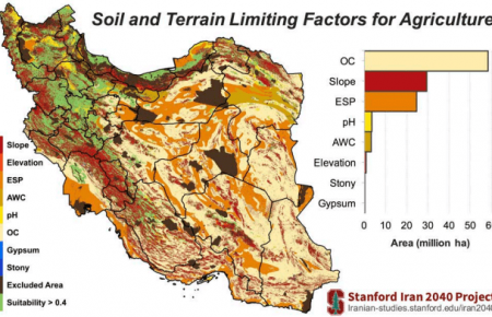
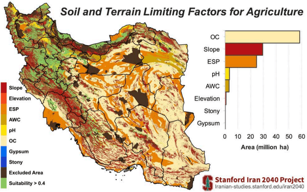
The spatial distribution of suitability classes shows that the vast majority of lands in the center, east and, southeast of Iran have a low potential for agriculture irrespective of water availability and other climate variables (Figure 3). As shown in Figure 4, the potential agricultural productivity in these regions is mainly constrained by the low amount of organic carbon (OC) and high levels of sodium contents (ESP). In general, Iran’s soil is poor in organic matters with 67% of the land area estimated to have less than 1% OC. Saline soils, defined by FAO [10] as soils with EC > 4 dS/m and pH < 8.2, are common in 41 million ha (25%) of Iran. Although many plants are adversely affected by the saline soils (EC > 4 dS/m), there are tolerant crops such as barley and sugar beet that can grow almost satisfactorily in soils with ECs as high as 20 dS/m [11], which was used as the upper limit of EC in this analysis. Although sodic soils (ESP > 15 and pH > 8.2 as per FAO’s definition [10]) are less abundant in Iran (~ 0.5 million ha), soils that only have high ESP (i.e. regardless of pH) covers ~30 million ha (18% of lands). We used 45% ESP as the upper limit for cropping since tolerant crops such as sugar beet and olive can produce acceptable yield at such high ESP levels [11]. As shown in Figure 4, EC is not listed among the limiting factors, while we know soil salinity is a major issue for agriculture in Iran. This discrepancy can be explained by prevalence of soils with ESP > 45 as compared to those with EC > 20 dS/m resulting in saline soils being masked by potentially sodic soils. That is, the total area of soils with EC > 20 dS/m was estimated to be about 6.4 million ha (4% of lands), while soils exceeding the ESP threshold of 45 constituted ~12 million ha (7%) i.e. almost double the size of saline soils.

Figure 3. Iran’s land suitability for agriculture based on soil and topographic variables. See Methods for the definitions of suitability classes.
Iran’s high quality lands for cropping (good and very good classes) are confined to a narrow strip along the Caspian Sea (Golestan, Mazandaran and Gilan provinces) and few other provinces in the west and northwest (e.g. West Azerbaijan, Kurdistan, and Kermanshah) (Figure 3). In the latter provinces, the main land limitations are high altitude and steep slopes (Figure 4) as these regions intersect with the two major mountain ranges in the north (Alborz) and west (Zagros).

Figure 4. Geographical distribution of the limiting soil and topographic factors for lands classified as unsuitable, very poor, and poor as shown in Figure 3. Suitability > 0.4 refers to as medium, good, and very good lands. See Nomenclature for the definitions of limiting factors shown in the legend.
Thus far, the land suitability analysis was based on soil and terrain conditions only, reflecting the potential agricultural productivity of Iran’s without consideration of the additional limitations imposed by the water availability and climatic variables. However, Iran is located in one of the driest areas of the world where water scarcity is a main constraint for agricultural production. Based on aridity index [12], we classify 98% of Iran as hyper arid, arid, or semi arid (Figure B1, Appendix B). August and January are the driest and wettest months in Iran, respectively, as shown in Figure 5. Over half of the country experiences hyper arid climate conditions for five successive months starting from June (Figure 5). This temporal pattern of aridity index has dire consequences for summer grown crops as the amount of available water and/or the rate of water uptake by the crop may not meet the atmospheric evaporative demand during these months, giving rise to very low yields or total crop failure. There is high degree of overlap between regions that experience wetter conditions for most of the year (Figure 5) and those identified as suitable for agriculture based on their soil and terrain conditions (Figure 3). This suggests that some of the land features relevant to cropping might be correlated with the climate parameters. It must be noted that the high ratio of precipitation (P) to potential evapotranspiration (PET) in humid regions could also result from low temperature rather than high precipitation. To incorporate climate variables into our land suitability analysis we used monthly precipitation and PET as measures of both general availability and temporal variability of water. We derived, from monthly precipitation and PET data, the length of the growing period across Iran (Figure 6). Growing period was defined as the number of consecutive months wherein precipitation exceeds half the PET [13]. As shown in Figure 6, areas where moisture conditions allow a prolonged growing period are predominately situated in the northern, northwestern, and western Iran with Gilan province exhibiting the longest growing period of 9 months. For over 50% of the lands in Iran, the length of moist growing period is too short (≤ ۲ months [11]) to support any cropping unless additional water is provided through irrigation (Figure 6). However, these areas, located in the central, eastern, and southeastern Iran, suffer from the shortage of surface and ground water resources to support irrigated farming in a sustainable manner. Taking into account daily climate data and all types of locally available water resources can improve the accuracy of the length of growing period estimation.

Figure 5. Temporal and geographical distributions of aridity classes in Iran.
By incorporating annual precipitation and length of the growing season into our land evaluation analysis, we were able to account for both the total amount and the temporal distribution of precipitation. The productivity of rainfed farming is also affected by the selection of planting date [14], which often depends on the timing of the first effective rainfall events. This factor (i.e. planting date) has been indirectly considered in the analysis when calculating the length of the growing period. For this joint soil-terrain-climate analysis, all regions with a growing season of two months or shorter were assigned a suitability value of zero and thus classified as unsuitable for agriculture. We then evaluated the capacity of land for rainfed farming by using a precipitation cut-off of 250 mm/y, which is often regarded as the minimum threshold for the rainfed farming (see Figure C1, Appendix C).

Figure 6. Spatial distribution of the length of the growing period (months) in Iran.
As shown in Table 2, the inclusion of the length of growing period and precipitation into the analysis only slightly reduced the total area of high quality lands (good and very good classes) from 5.8 to 5.4 million ha. This implies that most lands with suitable soil and terrain conditions also receive sufficient amount of moisture to sustain a productive rainfed agriculture. On the contrary, the area of unsuitable lands increased from 39.7 to 112.9 million ha when precipitation and duration of growing season thresholds were superimposed on the soil and topographic constraints. This increase in unsuitable acreage was mainly driven by the demotion of lands from the very poor class to the unsuitable class (Table 2). The addition of moisture constraints also reduced the area of medium suitability lands by 4.8 million ha. In summary, for the rainfed farming scenario, 125 million ha (77%) of Iran’s land might be classified as poor or lower ranks whilst only 18 million ha (11%) meet the required conditions for the medium or higher suitability classes (Table 2). The geographical distribution of these land classes is mapped in Figure 7. Almost the entire central Iran (Yazd, Semnan, Markazi, and Esfahan), and the vast majority of land area in the eastern (South Khorasn and the southern part of Khorasan Razavi), southeastern (Sistan and Baluchistan, and Kerman) and southern (Hormozgan and Bushehr) provinces were found to be unsuitable for rainfed cultivation. Almost half the area of Khuzestan and three quarters of Fars provinces were also characterized unsuitable. Over the entire east, only in the northern part of Khorasan Razavi, is there a belt of marginally suitable lands satisfying the requirements of a potentially prosperous rainfed agriculture.

Figure 7. Iran’s land suitability with potential for rained agriculture based on soil properties, terrain, and precipitation threshold of 250 mm/y.
In the next step of the analysis, the suitability of land was scaled with the annual precipitations over the range of 100 mm/y (minimum level) to 500 mm/y (optimal level). The lower limit (i.e. 100 mm/y) is deemed to exclude the desert areas for agricultural use [15] whilst the upper limit (i.e. 500 mm/y) represents a benign moisture environment for the growth of many crops [11][16] (see Figure C1, Appendix C). Here, we made no assumption as to whether the cropping practices rely on rainfall or irrigation for satisfying crop water requirement. The same minimum length of growing period (≥ ۲ months) and soil/topographic constraints as with the previous methods were used in this analysis. Compared to the rainfed agriculture analysis, the precipitation scaling method mainly changed the distribution of lands within the lower suitability classes (Table 1). For example, a great Page 13 proportion of lands within the unsuitable class was shifted up to the very poor and poor classes. The majority of high quality lands (i.e. good and very good), which also retain sufficient levels of moisture (i.e. good and very good classes) are located in the western and northern provinces of Iran (Figure 8). Kermanshah accommodates the largest area (763,000 ha) of such lands followed by Kurdistan (644,000 ha). High quality lands were estimated to cover 33% and 21% of these two provinces, respectively. Other provinces with high percentages of high quality lands were Gilan (24%), Mazandaran (16%), West Azerbaijan (14%), and Lorestan (14%). For 17 provinces, however, high quality lands covered less than 1% of their total area.

Figure 8. Iran’s agricultural land suitability based on soil properties, terrain, and climate conditions. Contrary to rainfed agriculture analysis (Figure 7), in this analysis the suitability of land increases with annual precipitation over the range of 100 to 500 mm/y.
To estimate the total area of croplands within each suitability class, we visually inspected 1.2 million ha of Iran’s land by randomly sampling images from Google Earth. We found that the proportion of land used for cropping increased almost linearly with the suitability values obtained from the precipitation scaling method (Figure 9). Total cropping area (harvested, fallow, and abandoned) in Iran was estimated to be about 24.6 million ha, which is far greater than the reported value (i.e. 14.5 million ha) by Iran’s Ministry of Agriculture [3][4]. This authority reports the harvested area; hence, the fallow or abandoned lands (i.e. those that might have once been cultivated) are not included in their calculation of active agricultural area. Our visual method, however, captures all lands that are currently under cultivation or had been used for cropping in the near past that are now in fallow or set-aside (but have yet retained the cultivation landmarks such as furrows). The relative distribution of croplands amongst the suitability classes (Figure 9) shows that about 52% (13 million ha) of the farmed areas are located in lands with their suitability classified as poor or lower ranks based on precipitation scaling method. Particularly concerning are the 4.2 million ha of lands (i.e. 17% of total agricultural area) that fall within the unsuitable class. Approximately 3.4 million ha (i.e. 14%) of cropping areas occur in good and very good lands (Figure 9), however, no agricultural expansion can be practiced in these areas as all available lands in these suitability classes have already been fully exploited. Medium quality lands comprise 12.8 million ha of Iran’s land surface area (Table 2), of which about 8.6 million hectares have been allocated to agriculture (i.e. 34% of total agricultural area). However, due to their sparse spatial distribution and lack of proper access, only a small portion of the unused lands with medium suitability (i.e. 4.2 million ha) can be practically deployed for agriculture. Using FAO’s spatial data on rainfed wheat yield in Iran [17], the mean yield for the six suitability classes were estimated (Table 3). As shown, the yield of the rainfed wheat increases proportionally with improving suitability index. Using the yield-suitability relationship, we estimate that 0.8 million ton of wheat grain might be produced per year by allocating 1 million ha of the unused lands from the medium suitability to rainfed wheat cropping. Redistribution of croplands from the low quality lands to more suitable ones has potentials to improve crop yields in Iran and thus represents a viable strategy to increase agricultural production without a need for cropping land expansion. Inefficient agricultural practices in unsuitable lands need to be avoided as they produce little yields at the cost of exacerbating land degradation and water scarcity problem. As was shown above, a small acreage of 1.0 million ha from the medium suitability areas may worth 5.5 million ha of lands in unsuitable or very poor areas in terms of the capacity for rainfed wheat production. Although this conclusion may not hold for other crops grown in Iran, the wheat crop could be a good candidate to make such a generalization as it is the most widely cultivated crop in the country (50% of total harvest area [3]) and is considered as a very low demanding plant, which has adapted to a broad range of contrasting environments. Redistribution of croplands, however, will not be a trivial task for both the Iranian decision makers and stakeholders due to different regional, societal, demographic, logistic, institutional, economic, and policy barriers. Lands found suitable for agriculture may not be easily accessible if scattered sparsely or occur in remote areas. Practicing certain industrial agriculture methods in the unsuitable lands might be a viable strategy to sustainably maintain these lands in the agricultural sector while avoiding the potential economic, social, and political costs associated with redistribution of agricultural lands and farming populations. For example, greenhouse facilities can be established at some of these locations to cope with both land suitability and water availability constraints. Climate in most areas identified as unsuitable can be characterized by sunny and warm days that are conducive to the development of a fruitful greenhouse farming. For example, there are areas in Sistan and Baluchestan, one of the driest regions in the southeast, multiple cropping can be practiced under greenhouse conditions because of a prolonged growing period of over 10 months. While water insufficiency is a major limiting factor for both field and greenhouse farming in this region, the latter will be affected to a lesser extent.
Table 3. Rainfed wheat yield for different land suitability classes estimated based on georeferenced data from FAO [17].


Figure 9. Distribution of Iran’s agricultural lands (cultivated or uncultivated) among different suitability classes corresponding to Figure 8. The left figure shows the percentage of the land within each of the suitability classes that have been used for cropping. The donut chart (right) shows the proportion of Iran’s total agricultural area that falls within each suitability class.
Concluding Remarks
We examined the capacity of Iran’s land for agriculture based on a large number of soil attributes and terrain and climate conditions at a very high resolution. We found that: 1- On top of the well-known water limitations, land resources also pose significant barriers to the sustainable development of agriculture in Iran. 2- A sizeable acreage of farmlands occurs in unsuitable and very poor suitability ranks. The production from these lands not only is low, but also can cause environmental damage and hence subject to further decline in the future. 3- Land expansion is unlikely to add significantly to Iran’s food production capacity. However, redistribution of lands from lower suitability ranks to more suitable lands can somewhat improve the overall sustainability of Iran’s agriculture. 4- Increased food production capacity can be achieved through adoption of certain modern agricultural practices (e.g. greenhouse farming) in areas where land suitability is not necessarily high. This study used precipitation as the only water availability factor. Including surface and ground water availability can further improve the analysis results. Given the good correlation between water availability and land suitability for agriculture, the general findings of this study are not expected to change significantly by the inclusion of water availability conditions. Nevertheless, due to the current water shortage constraints across the country, the potential agricultural capacity of the country is likely to decrease when water availability is added to the analysis. The next study will more closely look into the distribution of crops patterns and discuss the future of Iran’s agriculture in the contexts of freshwater consumption and the monetary value of products.
References [1] The World Bank Data, www.data.worldbank.org [2] An Statistical Overview of Field Crops Harvested Area and Production in the Past 36 Years, Iranian Ministry of Agriculture, 2015, (In Farsi) [3] Agriculture Statistics: Volume 1, Field Crops, Iranian Ministry of Agriculture, 2013 – ۲۰۱۴, (In Farsi). [4] Agriculture Statistics: Volume 2, Horticultural Crops, Iranian Ministry of Agriculture, 2013, (In Farsi) [5] FAOSTAT, Food Agriculture Organization of the United Nations, www.fao.org/faostat [6] P. Azadi, H. Dehghanpour, M. Sohrabi, K. Madani, The Future of Iran’s Oil and Its Economic Implications, Working Paper 1, Stanford Iran 2040 Project, Stanford University, October 2016, https://purl.stanford.edu/mp473rm5524 [7] K. Madani, A. Aghakouchak, A. Mirchi, Iran’s Socio-economic Drought: Challenges of a WaterBankrupt Nation, Iranian Studies, 49, 2016 [8] K. Madani, Water management in Iran: what is causing the looming crisis? Journal of Environmental Studies and Sciences, 4, 315-328, 2014 [9] R.J. Hijmans, S.E. Cameron, J.L. Parra, P.G. Jones, A. Jarvis, Very high resolution interpolated climate surfaces for global land areas. International journal of climatology, 25(15), 1965-1978, 2005 [10] I.P. Abrol, J.S.P. Yadav, F.I. Massoud, Salt-affected soils and their management. U.N. Food and Agric. Organ. Soils Bull. 39, Rome, 131, 1988 [11] C. Sys, E. van Ranst, J. Debaveye, F. Beernaert, Land evaluation. Part III: Crop requirements. Agric. Publ. 7. Administration for Dev. Coop., Brussels, Belgium, 1993 [12] United Nations Educational, Scientific and Cultural Organization (UNESCO), Map of the world distribution of arid regions: Map at scale 1:25,000,000 with explanatory note. MAB Technical Notes 7, UNESCO, Paris, 1979 [13] Report on the Agro-ecological Zones Project. Vol. 1, Methodology and results for Africa. World Soil Resources Report 48/1, FAO, Rome [14] M. Bannayan, E.E. Rezaei, G. Hoogenboom, Determining optimum planting dates for rainfed wheat using the precipitation uncertainty model and adjusted crop evapotranspiration, Agricultural water management, 126, 56-63, 2013 [15] M. Khosroshahi, M.T. Khashki, T.E. Moghaddam, Determination of climatological deserts in Iran. Iranian Journal of Range and Desert Research, 16(1), 96-113, 2009 [16] Food and Agriculture Organization of the United Nations, EcoCrop Database, FAO, Rome, Italy (www.ecocrop.fao.org), 2013 [17] FAO/IIASA, Global Agro-ecological Zones (GAEZ v3.0) Data Portal, FAO, Rome, Italy and IIASA, Laxenburg, Austria, 2011